As the ChEESE2 project approaches its conclusion, some of its most significant results can be measured not only in scientific publications or advances in computing, but in what happens when research reaches the people responsible for protecting society. In Andalusia, high-resolution tsunami simulations developed by researchers at the University of Málaga have helped translate scientific assessments of tsunami risk into Spain’s first regional tsunami emergency plan – and the collaboration behind it continues today.
The plan was formally approved by the Andalusian government in June 2023. But the story did not end there.
Since its approval, researchers from the EDANYA group at the University of Málaga have continued to work with Andalusia’s emergency-management authorities to update risk scenarios, refine operational procedures and support technical coordination. What began as a scientific effort to understand tsunami risk along the southern Spanish coast has evolved into an ongoing partnership between researchers and the institutions responsible for emergency preparedness.
From hazard modelling to emergency planning
Tsunamis are rare along Spain’s southern coast, but the risk is real – and when a tsunami does occur, the consequences can be severe. The 1755 Lisbon earthquake and tsunami, which killed tens of thousands of people and devastated Lisbon, remains a powerful reminder of the region’s vulnerability. The Gulf of Cádiz and the Alboran Sea lie close to active fault systems capable of generating tsunamis that can reach the Andalusian coast in as little as a few minutes, while in other scenarios the first waves may take up to around an hour to arrive.
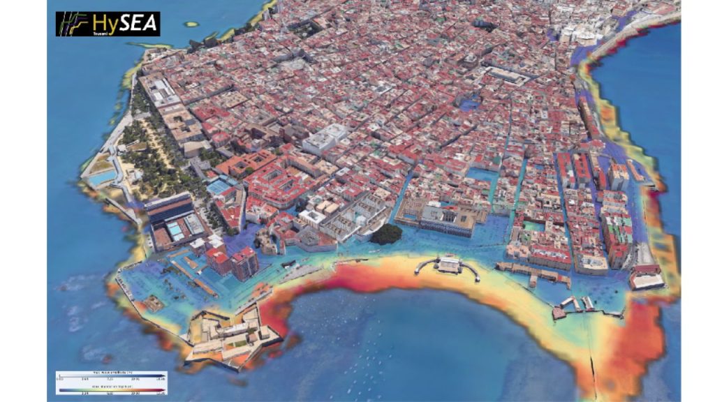
For decades, this risk was primarily the subject of scientific research. The work carried out by EDANYA, within the Centre of Excellence for Exascale in Solid Earth (ChEESE-2), helped change that by providing high-resolution numerical simulations of how tsunami waves could propagate and inundate the entire Andalusian coastline.
These simulations underpinned the Plan de Emergencia ante el Riesgo de Maremotos en Andalucía, formally approved by the Andalusian government in 2023. The plan is Spain’s first regional tsunami emergency plan and provides a comprehensive framework for preparing for and responding to tsunami risk along the Andalusian coast.
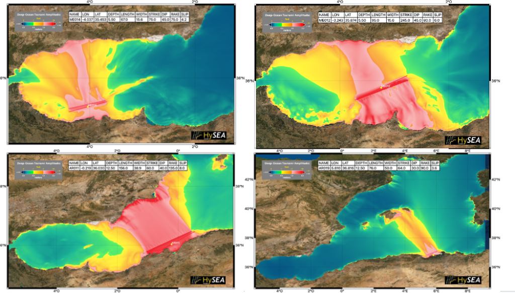
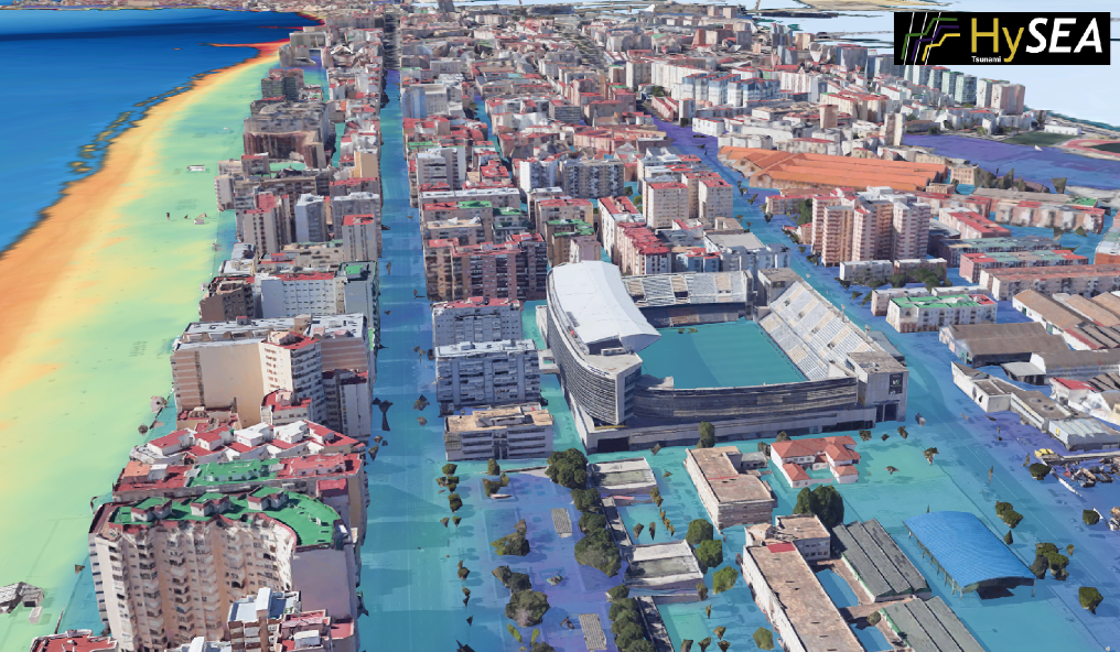
The scientific work behind it was unprecedented in scale. Using high-performance computing resources provided by the Spanish Supercomputing Network (RES) and the Center for Supercomputing and Bioinformatics (SCBI) at the University of Málaga, researchers modelled tsunami inundation across approximately 1,000 kilometres of coastline, from Huelva in the west to Almería in the east, at a resolution of five metres.
No previous study had combined this geographical scope with such a high-resolution simulation of tsunami inundation along an entire coastline.
The resulting scenarios provided detailed information on how tsunami waves could propagate and inundate coastal areas, down to individual beaches, ports and urban areas. This allowed emergency planners to move beyond a general understanding that “a tsunami could happen” towards specific, actionable questions: which coastal sectors should be prioritised, how evacuation routes should be designed, and what warning and response procedures should be put in place.
For a hazard where authorities may have only minutes to respond, that level of detail can make a critical difference. “We spent years developing increasingly precise numerical models to simulate how a tsunami would behave along our coast. Seeing that work turn into public policy – into something that guides real evacuation and warning decisions – is exactly the kind of impact we were aiming for when we started,” says Jorge Macías Sánchez, ChEESE researcher, Professor of Applied Mathematics at the University of Málaga (UMA) and member of the EDANYA research group.
A partnership that continued beyond the plan
The approval of the emergency plan could have marked the end of the research-policy journey. Instead, it became a new stage in the collaboration. EDANYA has continued working with the Agencia de Emergencias de Andalucía to update risk scenarios, improve operational procedures and contribute to technical coordination. This continued engagement has helped ensure that the scientific knowledge underpinning the plan can evolve alongside new data, advances in modelling capabilities and the changing needs of emergency-management authorities.
Alejandro García Hernández, Director General of Emergencies and Civil Protection for the Andalusian government, describes the collaboration as one that “extended well beyond the drafting stage”, with EDANYA supporting the updating of risk scenarios, improving operational procedures, participating in technical coordination activities and contributing scientific expertise to preparedness and response planning. In his written endorsement of the project, he describes the collaboration as “a model of evidence-informed policymaking with significant societal benefit.”
The Instituto Geográfico Nacional (IGN), which operates Spain’s National Tsunami Warning Centre, has also highlighted EDANYA’s contribution. In a letter supporting the collaboration, the IGN notes that the group’s advanced numerical modelling capabilities, hazard assessments and scenario analyses have supported understanding of tsunami impacts along vulnerable coastal sectors of southern Spain. According to the IGN, this work has also strengthened institutional preparedness and the integration of scientific evidence into operational decision-making.
Making supercomputing useful beyond the research community
The Andalusian case illustrates a central challenge in computational science: producing more powerful simulations is only part of the equation. Their value ultimately depends on whether the knowledge they generate can be translated into information that people outside the research community can understand and use.
In this case, high-performance computing enabled researchers to simulate tsunami behaviour at a level of detail that would not have been practical using conventional approaches. But the impact came from connecting those simulations with the people responsible for emergency planning.
The result was not simply a scientific model, but a practical evidence base for decisions about evacuation, preparedness and response. This is precisely the type of science-to-policy pathway that European disaster-risk-reduction frameworks seek to promote- and one that lies at the heart of ChEESE Project’s mission.
The project has focused on developing and preparing advanced, open-source Earth-science codes for the era of exascale computing. Yet the value of these technologies is ultimately measured not by their computational power alone, but by what they enable scientists and society to do with them.
Credits
- Published
- 07 September 2026
- Author
- Aerton Guimarães – ChEESE-2P Dissemination Team
- Simulations
- EDANYA Research Group